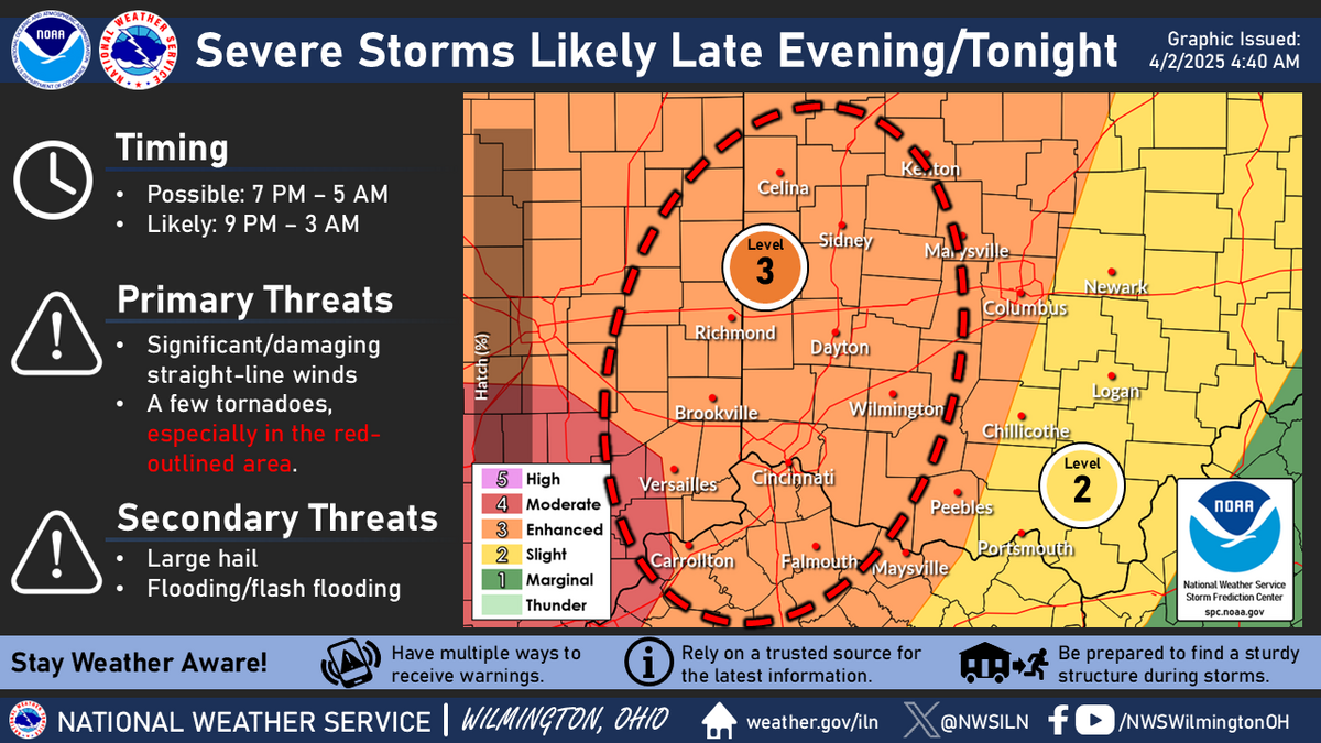
Some strong to severe storms possible this afternoon, primarily near and east of the I-75 corridor
Back To Weather Blog
Some strong to severe storms possible this afternoon, primarily near and east of the I-75 corridor
May 1, 2025
Scattered showers and storms are expected through the day today, with some strong to severe storms possible this afternoon, primarily near and east of the I-75 corridor. Although some storms may continue through this evening, the severe threat should wane into early evening.
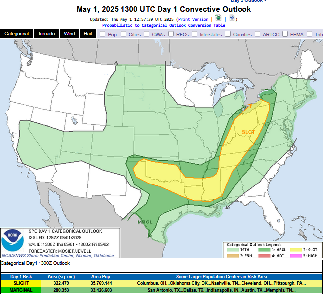
 Day 1 Convective Outlook
   NWS Storm Prediction Center Norman OK
   0757 AM CDT Thu May 01 2025

   Valid 011300Z - 021200Z

   ...THERE IS A SLIGHT RISK OF SEVERE THUNDERSTORMS FROM THE LOWER MS
   VALLEY THROUGH THE TN AND OH VALLEYS INTO THE LOWER GREAT
   LAKES...AND FROM THE TX/OK PANHANDLES EASTWARD ACROSS OK AND NORTH
   TX....

   ...SUMMARY...
   Lines and/or clusters of strong to severe thunderstorms are likely
   to impact parts of the Ohio Valley into lower Great Lakes, parts of
   the lower Mississippi Valley, and the southern Great Plains this
   afternoon through tonight.

   ...Synopsis...
   Early morning satellite imagery shows several shortwave troughs
   across the CONUS, including one entering the Lower MO Valley/Ozarks
   vicinity, another moving into NE, and another off the southern CA
   coast. The lead wave is forecast to progress quickly northeastward
   through the OH Valley and Great Lakes while losing amplitude under
   the increasingly confluent flow aloft. At the same time, another
   shortwave trough will drop southeastward through the northern High
   Plains into the northern/central Plains, leading to some
   amplification of the upper troughing across the north-central CONUS.

   Recent surface analysis revealed several lows within a broad area of
   low pressure across the central CONUS, one over west-central IL,
   another near the SD/ND/MN border intersection, and a third over
   north-central OK. A warm front extends eastward from the low over
   west-central IL, while modest troughing extends between the Upper
   Midwest low and the one over north-central OK.

   The west-central IL low is expected to deepen throughout the day as
   it moves northeastward ahead of its parent shortwave, with the
   attendant warm front advancing northward as well. The northernmost
   surface low is expected to progress slowly eastward as well, with
   its associated surface troughing also drifting eastward. A more
   stationary pattern is anticipated in the vicinity of the OK low
   throughout much of the period.

   ...TN/OH Valleys into the Lower Great Lakes...
   Low 60s dewpoints are already in place across the Lower OH and TN
   Valley this morning. Continued northward/northeastward advection of
   this low-level moisture is anticipated today as the surface low
   progresses northeastward. This increased moisture coupled with
   modest heating will help support moderate buoyancy across much of
   the region by early afternoon. Broad large-scale ascent and surface
   troughing are expected over the region amid this destabilization,
   which is forecast to result in widespread thunderstorms during the
   afternoon and evening. The convective mode will likely be dominated
   by linear structures, with one or more convective lines possible.
   Primary severe risk will be damaging gusts, supported by moderate
   southwesterly flow in the lower troposphere. Some hail is also
   possible, particularly during cell mergers. The tornado risk will be
   low but non-zero, as veered low-level flow limits the low-level
   shear.

   ...Lower MS Valley...
   The airmass across the region is expected to quickly destabilize as
   low-level moisture advects back into the region in the wake of the
   convection currently moving through. Upper 60s dewpoints coupled
   with modest heating will result in moderate to strong buoyancy and
   no convective inhibition by the early afternoon. Even modest
   low-level convergence should be enough to initiate deep convection,
   but any remnant outflow could also act as a focus for convective
   initiation. Robust updrafts are expected with initial development,
   with a quick trend towards outflow-dominant structures. Large hail
   and damaging gusts are the primary risks.

   ...TX/OK Panhandles into much of OK and north TX...
   Low-level moisture is expected to advect back northwestward into the
   TX Panhandle throughout the day. Cold mid-level temperatures are
   already in place (-16 deg C at 500 on the 12Z AMA sounding), so this
   added low-level moisture coupled with glancing ascent will likely
   result in late evening thunderstorm development. Most of the
   convection-allowing guidance is suggesting these storms will grow
   upscale quickly into an MCS, with some of guidance suggesting it
   could be quite and capable of producing significant wind gusts as it
   moves eastward across the TX Panhandle and into OK.

   Additionally, gradual increase in the low-level moisture beneath
   cold mid-level temperatures and associated steep mid-level lapse
   rates will result in strong buoyancy across southern OK. Modest
   warm-air advection could result in convective initiation across this
   region amid an environment that supports very large hail.

   Complex interaction is possible between the potential MCS and the
   more cellular development ahead of it, but some severe threat
   appears possible through early tomorrow morning.

   ..Mosier/Jewell.. 05/01/2025