Severe weather threat Thursday and Friday.
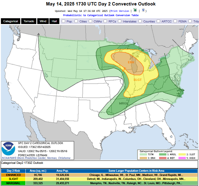
 ...THERE IS AN ENHANCED RISK OF SEVERE THUNDERSTORMS THURSDAY FROM
   EAST-CENTRAL MINNESOTA INTO MUCH OF WISCONSIN...NORTHEAST
   ILLINOIS...SOUTHWEST LOWER MICHIGAN...AND NORTHERN INDIANA...

   ...SUMMARY...
   Severe thunderstorms are expected across parts of the upper
   Mississippi River Valley and Great Lakes region Thursday afternoon
   and evening. The primary risk with this activity is large to very
   large hail, tornadoes (a couple may be strong), and scattered wind
   damage.

   More isolated severe thunderstorms are expected through the lower
   Ohio River Valley, Ozarks Plateau, and parts of the Mid-Atlantic.
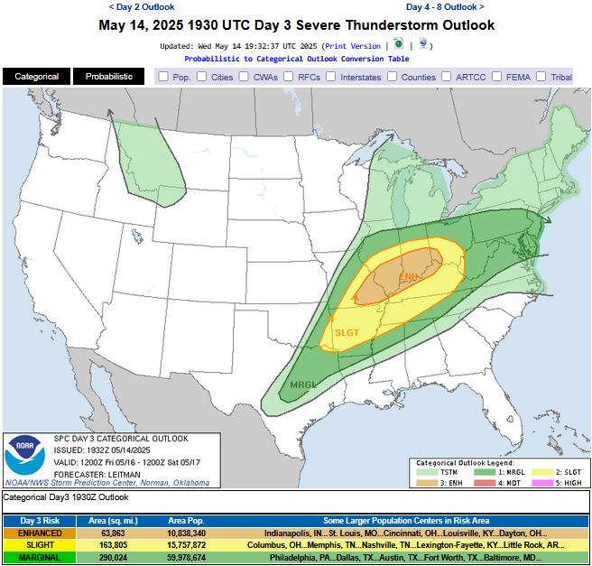
...THERE IS AN ENHANCED RISK OF SEVERE THUNDERSTORMS FRIDAY IN SOUTHEAST
   MISSOURI...SOUTHERN ILLINOIS/INDIANA...SOUTHWEST OHIO...AND PORTIONS
   OF WESTERN TO NORTHERN KENTUCKY...

   ...SUMMARY...
   Severe thunderstorms are expected across the Middle Mississippi and
   Ohio Valley region Friday afternoon and evening. All-severe hazards
   are possible with this activity. More isolated severe thunderstorms
   will extend southwestward into northeast Texas, and northeast into
   the Mid-Atlantic.

   Given vertically veering supercell wind profiles, significant severe storms appear
possible -- with a risk for all hazards accompanying this activity, including very
large hail, tornadoes, and intense wind gusts.
The threat exists for severe thunderstorms with damaging winds, hail, heavy rains, and even tornadoes on Thursday and Friday. It is important to note that there is considerable uncertainty as to how this might evolve. On Thursday there will be a strong cap in the atmosphere which will inhibit thunderstorm development. It is possible that thunderstorms would not form at all but if they do, which would likely be late day or evening, they could rapidly become quite severe. On Friday there is also a severe storm chance with storm development being even more likely. Once again, all modes of severe storms are possible including tornadoes. Considering the still present degree of uncertainty you are urged to keep up with later statements and possible watches and warnings as we approach Thursday late afternoon and Friday late afternoon.
It currently appears that we will have a very nice weekend.