Increasing flooding concerns on area rivers. Expected to be the worst flooding in a number of years. Still a severe risk
Back To Weather Blog
Increasing flooding concerns on area rivers. Expected to be the worst flooding in a number of years. Still a severe risk
Apr 4, 2025
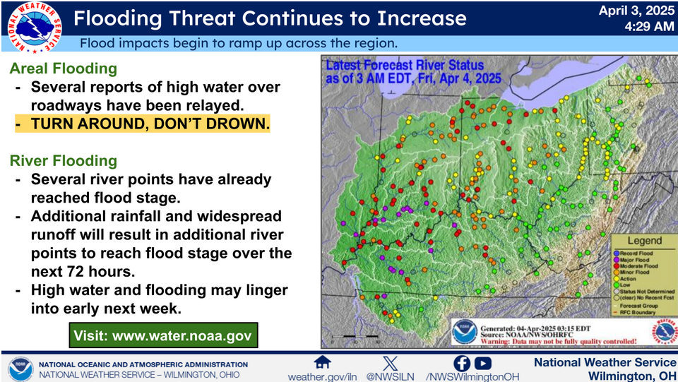
Areal Flooding Several reports of high water over roadways have been relayed. TURN AROUND, DON'T DROWN. River Flooding Several river points have already reached flood stage. Additional rainfall and widespread runoff will result in additional river points to reach flood stage over the next 72 hours. High water and flooding may linger into early next week. Visit www.water.noaa.gov for additional details!

Friday severe risk

Saturday severe risk

2-3 inches of additional rain expected through Sunday in the Cincinnati tristate
...The Flood Warning continues for the following rivers...
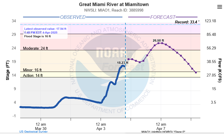
Great Miami River at Miamitown.
PRECAUTIONARY/PREPAREDNESS ACTIONS...
Turn around, don`t drown when encountering flooded roads. Most flood
deaths occur in vehicles.
Additional information is available at www.weather.gov/iln.
&&
OHC061-050500-
/O.EXT.KILN.FL.W.0023.000000T0000Z-250409T1642Z/
/MIAO1.2.ER.250404T0848Z.250407T0000Z.250409T1042Z.NO/
1248 PM EDT Fri Apr 4 2025
...FLOOD WARNING NOW IN EFFECT UNTIL EARLY WEDNESDAY AFTERNOON...
* WHAT...Minor flooding is occurring and moderate flooding is
forecast.
* WHERE...Great Miami River at Miamitown.
* WHEN...Until early Wednesday afternoon.
* IMPACTS...At 26.0 feet, Water covers Harrison Pike in and near
Miamitown. This affects several businesses east of river,
including the Blue Bell Beach Lounge and Riverfront West Sports
Complex. Moderate flooding also continues along the river in low
spots through southwest Miami Township. Significant flooding also
continues downstream of Miamitown in Miami and Whitewater
Townships.
* ADDITIONAL DETAILS...
- At 11:45 AM EDT Friday the stage was 18.2 feet.
- Forecast...The river is expected to rise to a crest of 20.6
feet this evening. The river will then continue to rise to
26.5 feet by Monday morning. It will then fall below flood
stage Wednesday morning.
- Flood stage is 16.0 feet.
&&
LAT...LON 3930 8467 3931 8463 3931 8460 3920 8469
3911 8482 3915 8482
$$
Clark
Flood Warning
Flood Warning
National Weather Service Wilmington OH
1224 PM EDT Fri Apr 4 2025
...The National Weather Service in Wilmington has issued a Flood
Warning for the following rivers...
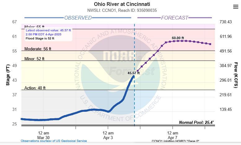
Ohio River at Cincinnati.
PRECAUTIONARY/PREPAREDNESS ACTIONS...
Turn around, don`t drown when encountering flooded roads. Most flood
deaths occur in vehicles.
Additional information is available at www.weather.gov/iln.
&&
INC029-115-KYC015-037-117-OHC025-061-050430-
/O.NEW.KILN.FL.W.0037.250405T1531Z-000000T0000Z/
/CCNO1.2.ER.250405T1531Z.250407T1200Z.000000T0000Z.NO/
1224 PM EDT Fri Apr 4 2025
...FLOOD WARNING IN EFFECT FROM SATURDAY MORNING UNTIL FURTHER
NOTICE...
* WHAT...Moderate flooding is forecast.
* WHERE...Ohio River at Cincinnati.
* WHEN...From Saturday morning until further notice.
* IMPACTS...At 60.0 feet, Significant flooding in East End,
California and New Richmond in Ohio, with backwater floods in
Silver Grove, KY, and riverfront buildings in Aurora Indiana.
Stretches of U.S. 52 are flooded, with numerous additional low
lying roads near the river flooded. Backwater flooding along the
Little Miami, Great Miami and Licking Rivers, also result in road
closures. Some main level of homes flooded in the East End
sections of Cincinnati.
* ADDITIONAL DETAILS...
- At 12:00 PM EDT Friday the stage was 44.8 feet.
- Forecast...The river is expected to rise above flood stage
late Saturday morning and continue rising to a crest of 60.0
feet Monday morning.
- Flood stage is 52.0 feet.
&&
LAT...LON 3890 8418 3885 8429 3906 8448 3903 8493
3916 8490 3914 8437
$$
Clark
Flood Warning
Flood Warning
National Weather Service Wilmington OH
1156 AM EDT Fri Apr 4 2025
...The National Weather Service in Wilmington has issued a Flood
Warning for the following rivers...
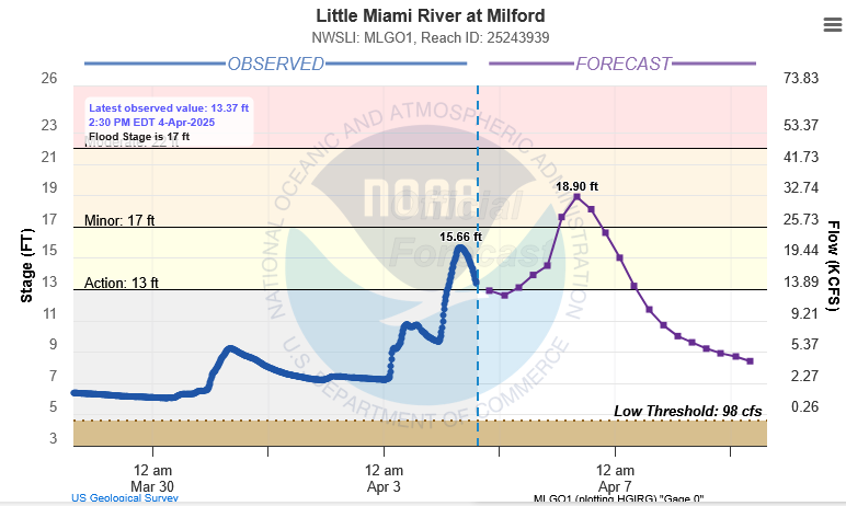
Little Miami River at Milford.
PRECAUTIONARY/PREPAREDNESS ACTIONS...
Turn around, don`t drown when encountering flooded roads. Most flood
deaths occur in vehicles.
Additional information is available at www.weather.gov/iln.
&&
OHC025-061-050400-
/O.NEW.KILN.FL.W.0036.250406T0450Z-250407T0425Z/
/MLGO1.1.ER.250406T0450Z.250406T1200Z.250406T2224Z.NO/
1156 AM EDT Fri Apr 4 2025
...FLOOD WARNING IN EFFECT FROM LATE SATURDAY NIGHT TO EARLY MONDAY
MORNING...
* WHAT...Minor flooding is forecast.
* WHERE...Little Miami River at Milford.
* WHEN...From late Saturday night to early Monday morning.
* IMPACTS...At 19.0 feet, Flooding occurs in lowland areas of
Milford and Terrace Park, including portions of Round Bottom Road
in Anderson Township and Karl Brown Way near the railway
underpass, Cones Road and Cox Trailside Parking lot in Loveland.
* ADDITIONAL DETAILS...
- At 11:30 AM EDT Friday the stage was 14.8 feet.
- Forecast...The river is expected to rise above flood stage
early Sunday morning to a crest of 18.9 feet Sunday morning.
It will then fall below flood stage Sunday evening.
- Flood stage is 17.0 feet.
&&
LAT...LON 3929 8428 3929 8426 3927 8425 3916 8428
3907 8443 3910 8443
$$
Clark
Flood Watch
Flood Watch
National Weather Service Wilmington OH
302 PM EDT Fri Apr 4 2025
INZ050-058-059-066-073>075-080-KYZ089>100-OHZ026-034-035-042>046-
051>056-060>065-070>074-077>082-088-050315-
/O.CON.KILN.FA.A.0003.000000T0000Z-250406T1200Z/
/00000.0.ER.000000T0000Z.000000T0000Z.000000T0000Z.OO/
Wayne-Fayette-Union-Franklin-Ripley-Dearborn-Ohio-Switzerland-
Carroll-Gallatin-Boone-Kenton-Campbell-Owen-Grant-Pendleton-
Bracken-Robertson-Mason-Lewis-Hardin-Mercer-Auglaize-Darke-Shelby-
Logan-Union-Delaware-Miami-Champaign-Clark-Madison-Franklin-
Licking-Preble-Montgomery-Greene-Fayette-Pickaway-Fairfield-
Butler-Warren-Clinton-Ross-Hocking-Hamilton-Clermont-Brown-
Highland-Adams-Pike-Scioto-
Including the cities of Sidney, Hidden Valley, Maysville, Osgood,
New Bremen, Oakbrook, Newport, Tollesboro, Vanceburg, Xenia,
Mount Orab, Versailles, London, Coldwater, Newark, Head Of
Grassy, Georgetown, Bright, Celina, Alexandria, Troy, Wilmington,
Eaton, Owenton, West Jefferson, Batesville, Florence, Ripley,
Peebles, Bellefontaine, Oxford, Springboro, Lawrenceburg,
Beavercreek, Mount Olivet, Minster, Dayton, Rising Sun, Camp Dix,
Circleville, Crittenden, Franklin, Hamilton, Bellevue, Liberty,
Mount Carmel, Ada, Aberdeen, Fairborn, Vevay, Burlington,
Downtown Columbus, Urbana, Downtown Dayton, Piketon, Milford,
Washington Court House, West Union, Brookville, Fairfield,
Downtown Cincinnati, Richmond, Lancaster, Williamstown, St.
Marys, Kettering, Camden, Dry Ridge, Pickerington, Fort Thomas,
Plain City, Aurora, Independence, Butler, Portsmouth, Middletown,
Summerside, Landen, Dillsboro, Brooksville, Augusta, Chillicothe,
Seaman, Mulberry, Greenfield, Erlanger, Delaware, Springfield,
Mason, Pike Lake, Warsaw, Carrollton, Piqua, Tipp City,
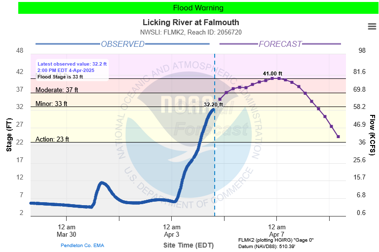
Hillsboro, Falmouth, Waverly, Mount Repose, Logan, Wapakoneta,
Winchester, Connersville, Highland Heights, West College Corner,
Blanchester, Milan, Greenville, Day Heights, Wheelersburg,
Withamsville, Lebanon, Covington, Greendale, Kenton, Manchester,
and Marysville
302 PM EDT Fri Apr 4 2025
...FLOOD WATCH REMAINS IN EFFECT THROUGH SUNDAY MORNING...
* WHAT...Flooding caused by excessive rainfall continues to be
possible.
* WHERE...The following counties, in Indiana, Dearborn, Fayette,
Franklin, Ohio, Ripley, Switzerland, Union and Wayne, the
following counties, in Kentucky, Boone, Bracken, Campbell,
Carroll, Gallatin, Grant, Kenton, Lewis, Mason, Owen, Pendleton
and Robertson, and the following counties, in Ohio, Adams,
Auglaize, Brown, Butler, Champaign, Clark, Clermont, Clinton,
Darke, Delaware, Fairfield, Fayette, Franklin, Greene, Hamilton,
Hardin, Highland, Hocking, Licking, Logan, Madison, Mercer, Miami,
Montgomery, Pickaway, Pike, Preble, Ross, Scioto, Shelby, Union
and Warren.
* WHEN...Through Sunday morning.
* IMPACTS...Soils remain moist and excessive runoff may result in
flooding of rivers, creeks, streams, and other low-lying and
flood-prone locations.
* ADDITIONAL DETAILS...
- Multiple rounds of showers and thunderstorms will occur into
the weekend with the heaviest rain expected Saturday into
Saturday night.
PRECAUTIONARY/PREPAREDNESS ACTIONS...
People in the watch area, especially those living in areas prone to
flooding, should be prepared to take action should flooding develop.
Monitor the latest forecasts and be alert for possible flood
warnings.
&&
$$
AR
Hazardous Weather Outlook
Hazardous Weather Outlook
National Weather Service Wilmington OH
516 AM EDT Fri Apr 4 2025

INZ050-058-059-066-073>075-080-KYZ089>100-OHZ042-045-046-051>056-
060>065-070>074-077>082-088-051100-
Wayne-Fayette-Union-Franklin-Ripley-Dearborn-Ohio-Switzerland-
Carroll-Gallatin-Boone-Kenton-Campbell-Owen-Grant-Pendleton-Bracken-
Robertson-Mason-Lewis-Darke-Delaware-Miami-Champaign-Clark-Madison-
Licking-Preble-Montgomery-Greene-Pickaway-Fairfield-Butler-Warren-
Clinton-Ross-Hocking-Hamilton-Clermont-Brown-Highland-Adams-Pike-
Scioto-
516 AM EDT Fri Apr 4 2025

...FLOOD WATCH REMAINS IN EFFECT THROUGH SUNDAY MORNING...

This Hazardous Weather Outlook is for east central Indiana,
southeast Indiana, northeast Kentucky, northern Kentucky, central
Ohio, south central Ohio, southwest Ohio and west central Ohio.

.DAY ONE...Today and tonight.

Please listen to NOAA Weather Radio or go to weather.gov on the
Internet for more information about the following hazards.

   Flood Watch.

.DAYS TWO THROUGH SEVEN...Saturday through Thursday.

Please listen to NOAA Weather Radio or go to weather.gov on the
Internet for more information about the following hazards.

   Flood Watch.

In addition, a few strong to severe storms will be possible Saturday
afternoon and evening. Damaging winds and large hail will be the
primary severe weather threats.

.SPOTTER INFORMATION STATEMENT...

Spotter activation is not expected at this time.

$$