Heavy rain and flash flooding possible overnight
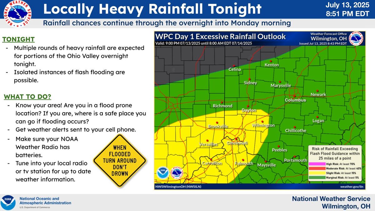
Showers and storms move into the region overnight, some of which may be heavy in nature. Areas where heavy storms occur may experience isolated flash flooding. ![]()
Very high rainfall rates will be capable of reaching 2 to 3 inches/hour. Isolated rainfall totals of 3-4 inches will be possible.
Make sure you have a way to receive weather alerts overnight.
There will be more isolated flooding potential this week in the Ohio valley, perhaps becoming a bit more widespread late in the week.

Mesoscale Precipitation Discussion 0675
NWS Weather Prediction Center College Park MD
610 PM EDT Sun Jul 13 2025

Areas affected...Portions of the OH Valley

Concerning...Heavy rainfall...Flash flooding possible

Valid 132210Z - 140410Z

SUMMARY...Heavy showers and thunderstorms will continue to impact
portions of the OH Valley going through the evening hours.
Isolated to scattered areas of flash flooding will continue to be
possible, and especially around the more urbanized locations.

DISCUSSION...GOES-E IR satellite imagery shows cold convective
tops associated with heavy showers and thunderstorms across
southeast IL and portions of central and southern IN. The activity
remains focused ahead of a well-defined mid-level vort
center/shortwave trough and an accompanying area of surface low
pressure which is transiting a frontal zone.

MLCAPE values over the Lower OH Valley are generally on the order
of 1500 to 2500 J/kg, and this coupled with anomalous PWs of 2.0
to 2.25 inches will continue to favor very high rainfall rates
that will be capable of reaching 2 to 3 inches/hour.

Generally the convection should continue to advance off to the
east, but there will be some relatively slow cell-motions, and
pockets of localized cell-training and cell-merger activity that
may allow for some rainfall totals to reach as high as 3 to 4+
inches by late this evening.

This is supported by a consensus of the 18Z HREF and 12Z REFS
guidance. However, the latest hires guidance does appear to be a
bit slow with the overall downstream convective evolution. Based
on the latest satellite and radar trends, convection should
advance across southern IN and into western OH by late-evening.

Given the high rainfall rates and localized concerns for
cell-training, isolated to scattered areas of flash flooding will
continue to be possible. This will include concerns for the more
sensitive urbanized locations.
What is the difference between a Flood Watch and a Flood Warning issued by the National Weather Service?
-
Flash Flood Warning: Take Action! A Flash Flood Warning is issued when a flash flood is imminent or occurring. If you are in a flood prone area move immediately to high ground. A flash flood is a sudden violent flood that can take from minutes to hours to develop. It is even possible to experience a flash flood in areas not immediately receiving rain.
Flash Flood Warnings are changing to an Impact-Based format to improve public response. Read the factsheet. -
Flood Warning: Take Action! A Flood Warning is issued when the hazardous weather event is imminent or already happening. A Flood Warning is issued when flooding is imminent or occurring.
-
Flood Advisory: Be Aware: A Flood Advisory is issued when a specific weather event that is forecast to occur may become a nuisance. A Flood Advisory is issued when flooding is not expected to be bad enough to issue a warning. However, it may cause significant inconvenience, and if caution is not exercised, it could lead to situations that may threaten life and/or property.
-
Flood Watch: Be Prepared: A Flood Watch is issued when conditions are favorable for a specific hazardous weather event to occur. A Flood Watch is issued when conditions are favorable for flooding. It does not mean flooding will occur, but it is possible.
![]()
Arbor Doctor LLC is certified by the National Weather Service as an official Weather-Ready Nation Ambassador.
The Weather-Ready Nation (WRN) Ambassador™ is a program of the U.S. Department of Commerce, National Oceanic and Atmospheric Administration (NOAA), designed to strengthen partnerships with external organizations toward building community resilience in the face of increasing vulnerability to extreme weather, climate, and water events. WRN Ambassadors serve as change agents and leaders in their community. They inspire others to be better informed and prepared, thus helping to minimize, mitigate, or avoid the impacts of natural disasters.
To learn more about the Weather-Ready Nation program, visit the WRN web site at: https://www.weather.gov/wrn/