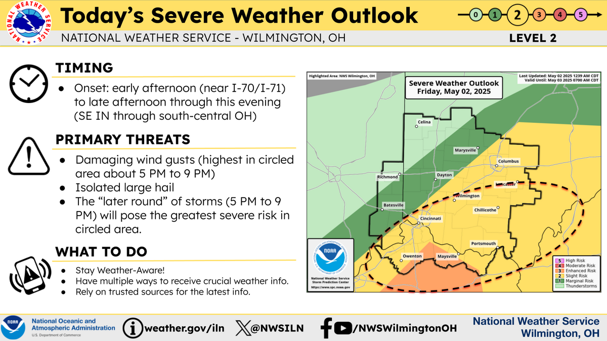
Another severe weather threat for May 2, 2025.
More storms are expected this afternoon, with an initial round of storms expected near the I-70 and I-71 corridors early to mid afternoon, with the greatest severe threat expected to evolve with several linear clusters of storms very late afternoon into early evening near and southeast of I-71. The early evening time period will likely be the highest severe risk, with damaging winds being the primary threat.
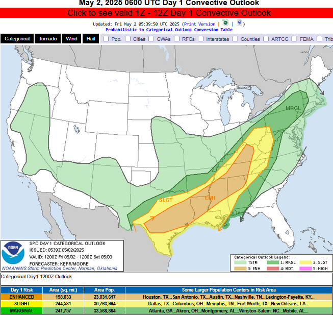
Day 1 Convective Outlook
   NWS Storm Prediction Center Norman OK
   1239 AM CDT Fri May 02 2025

   Valid 021200Z - 031200Z

   ...THERE IS AN ENHANCED RISK OF SEVERE THUNDERSTORMS TODAY INTO THIS
   EVENING ACROSS PARTS  OF CNTRL/ERN KY...MIDDLE AND ERN TN...NWRN
   GA...NRN AL...NRN AND CNTRL MS...SERN AR...NRN AND CNTRL LA...CNTRL
   AND ERN TX...

   ...SUMMARY...
   Widespread strong thunderstorm development, potentially including
   several organizing clusters, appears likely in a corridor across
   parts of central and eastern Texas, through the lower Mississippi
   and Tennessee Valleys, into the Cumberland Plateau by this evening.
   These may be accompanied by a risk for large hail, initially, before
   widespread strong to severe gusts becomes more common.

   ...Discussion...
   Although a mid/upper high may be attempting to form east of the
   Cascades, within large-scale riding shifting inland of the Pacific
   coast, models suggest that this will be short-lived.  And it appears
   that the ridging will slowly continue eastward across the
   Intermountain West and Rockies through this period, as one upstream
   short wave trough pivots northward across British Columbia, and
   another digs toward the northern Pacific coast.  Downstream, a
   significant short wave trough, currently digging to the lee of the
   northern Rockies, is forecast to continue across the central Great
   Plains through lower Missouri Valley and Ozark Plateau vicinity by
   12Z Saturday.

   It still appears that the trough over the Great Plains will be
   preceded by a convectively augmented short wave perturbation, just
   now beginning to evolve across the Texas Panhandle into Red River
   vicinity, and forecast to accelerate north-northeastward through the
   Ohio Valley later today and tonight.  Trailing this feature, a
   front, probably reinforced by considerable outflow from overnight
   convection, is forecast to advance south/southeast of the Red River
   and Ozark Plateau vicinity by 12Z this morning.  Ahead of this
   front, models indicate that a seasonably moist boundary layer will
   become characterized by sizable CAPE, with insolation beneath
   initially steep mid-level lapse rates, across much of central and
   southern Texas through the lower Mississippi Valley.  By late
   afternoon, low-level moisture advection may contribute to similar
   destabilization in a corridor across the Tennessee Valley into the
   western slopes of the Appalachians.

   ...Southern Great Plains into western slopes of Appalachians...
   While it is possible that one more prominent surface frontal wave
   may eventually form across parts of the Mid South into lower Ohio
   Valley late today into tonight, it appears that this may remain
   relatively weak, and the surface front may tend to advance south of
   the stronger mid-level westerlies.  However, models indicate that
   the environment within the developing instability axis will become
   at least modestly sheared, as broadly difluent mid/upper flow
   downstream of the digging trough supports increasing and
   intensifying thunderstorm development by midday.

   This may include re-intensification of overnight storms across the
   Mid South into Ohio Valley, and the initiation of additional storms
   southwestward across central Texas.  There is a considerable signal
   in model output that convection will become widespread, with
   potential for the evolution of at least a couple of notable
   organizing storm clusters.

   Initial thunderstorm development may be accompanied by the risk for
   large hail, particularly across central Texas, but perhaps also
   across and northeast of the lower Mississippi Valley.  Thereafter,
   precipitation loading, evaporative cooling and melting may
   contribute to strong downbursts, before convectively generated
   surface cold pools consolidate and strengthen, accompanied by
   increasingly widespread strong to severe gusts as convection spreads
   eastward and southeastward into this evening.

   ..Kerr/Moore.. 05/02/2025

   CLICK TO GET WUUS01 PTSDY1 PRODUCT

   NOTE: THE NEXT DAY 1 OUTLOOK IS SCHEDULED BY 1300Z
   CURRENT UTC TIME: 1128Z (7:28AM), RELOAD THIS PAGE TO UPDATE THE TIME
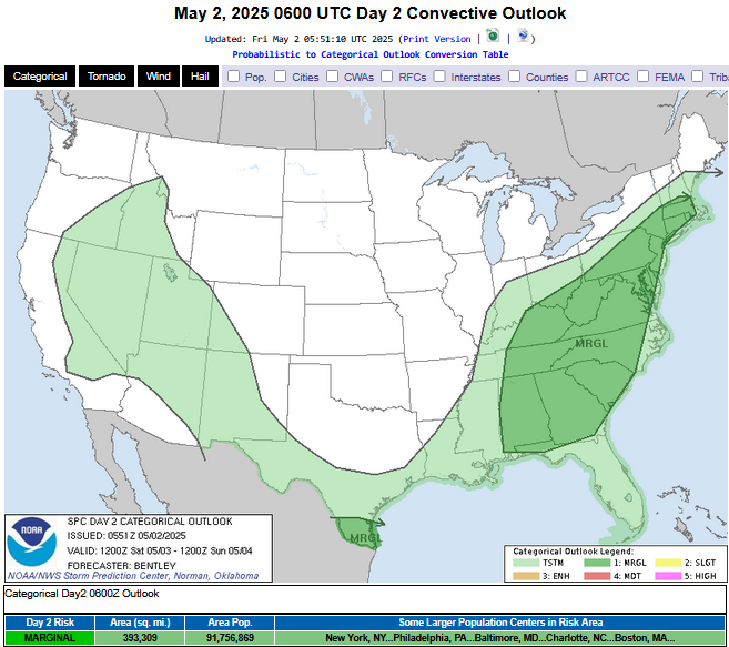
Day 2 Convective Outlook
   NWS Storm Prediction Center Norman OK
   1251 AM CDT Fri May 02 2025

   Valid 031200Z - 041200Z

   ...THERE IS A MARGINAL RISK OF SEVERE THUNDERSTORMS MAINLY SATURDAY
   AFTERNOON/EVENING FROM THE SOUTHEAST INTO THE MID-ATLANTIC AND
   SOUTHERN NEW ENGLAND...

   ...SUMMARY...
   Isolated strong to severe storms are possible on Saturday from the
   Southeast to southern New England and across deep South Texas.

   ...Synopsis...
   A mid-level low will become closed across the Midwest on Saturday
   with an associated surface low traversing along the Ohio River. A
   cold front will extend southwest from this surface low to South
   Texas Saturday morning with the cold front crossing the Appalachians
   by Saturday evening.

   ...Mid-Atlantic to the Southeast...
   A broad warm sector featuring low to mid 60s dewpoints will be in
   place ahead of the aforementioned cold front on Saturday morning.
   Convection will likely be ongoing along this front at the beginning
   of the period. This convection and associated cloud cover will
   likely inhibit destabilization ahead of the front with only weak
   instability forecast. Flow will be sufficient for some clusters or
   organized bowing segments, but the limited instability will probably
   limit a greater threat.

   Less cloudcover and greater destabilization is likely east of the
   Appalachians which could lead to a locally greater severe weather
   threat. Forecast soundings show around 35 to 45 knots of deep layer
   shear which could result in some organized storms. However, this
   threat should be short-lived as inhibition increases substantially
   after sunset.

   ...Deep South Texas...
   The majority of guidance shows the cold front/composite outflow in
   the Gulf/northern Mexico by 12Z Saturday, but some guidance (Hires
   NAM and somewhat the NSSL-WRF) shows a less progressive/slower
   southward movement of the boundary. Therefore, while a marginal
   severe weather risk appears less likely across Deep South Texas on
   Day 2/Saturday, the threat will be maintained for now since some
   guidance indicates the threat could exist and only slight timing
   differences from other guidance could result in some threat early on
   Day 2.

   ..Bentley.. 05/02/2025

   CLICK TO GET WUUS02 PTSDY2 PRODUCT

   NOTE: THE NEXT DAY 2 OUTLOOK IS SCHEDULED BY 1730Z
   CURRENT UTC TIME: 1131Z (7:31AM), RELOAD THIS PAGE TO UPDATE THE TIME
1-3 Day Rainfall (melted snow) Forecast: